St. Louis is known for being a car city, but there are many commuters who depend on public transportation to get to their jobs, schools and events around the region.
Reasons to use it include avoiding traffic jams and reducing smog and air pollution by limiting emission-producing vehicles on the roads. Public transportation also serves as an alternative for those who physically cannot drive, and it can be more affordable than the costs of purchasing and maintaining a car.
To the uninitiated, navigating St. Louis’ public transit system can feel intimidating. Here’s what you should know about how to move around the region by bus, light-rail train, trolley and call-a-ride services.
How to buy Metro tickets
Metro, the region’s main transit system, is operated by Bi-State Development. Between St. Louis Lambert International Airport in Missouri and Scott Air Force Base in Illinois, the system spans 38 miles.
Metro offers three types of passes for riders, in addition to single-use tickets. Current passes offered include:
- A standard monthly pass for $78.
- Reduced fare passes, including a half-price rate for seniors and discounts for Missouri or Illinois residents with disabilities.
- A one-day “STL Adventure Pass” for $5, valid for unlimited MetroLink and MetroBus services.
- Free MetroLink and MetroBus passes for 13- to 25-year-old residents of St. Louis. The program for city residents, called the Gateway Go Pass, runs through December 2024 and is funded by the American Rescue Plan.
Riders can buy single-ride tickets for MetroBus online, or by inserting cash payment into the farebox near the door, but keep in mind: You must have exact change. Debit and credit cards are not accepted. There are ticket machines at MetroLink stations that accept cards and give cash change.
Metro Transit tickets and passes are also available for purchase from MetroStore and other stores throughout the St. Louis region.
MetroBus
There are 59 MetroBus routes in the region — 46 that operate in St. Louis and St. Louis County and 13 that operate in St. Clair County in Illinois.
To navigate bus routes, use Metro’s online Trip Planner or download the Transit app on your mobile device. To contact Metro to ask a question or report an issue, text the customer service line at 314-207-9786 or the public safety line at 314-300-0188.
MetroLink
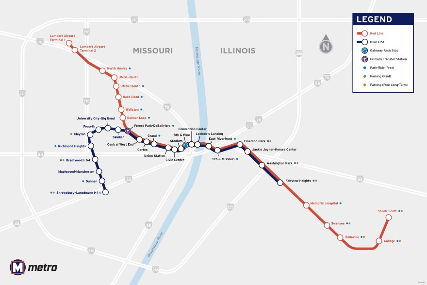
There are currently 39 MetroLink stations along two lines across the St. Louis area. The red line runs between St. Louis Lambert Airport Terminal 1 in north St. Louis County and Shiloh-Scott MetroLink Station in the Metro East. The blue line runs between the Shrewsbury-Lansdowne I-44 station near the St. Louis southwest city-county border and the Fairview Heights station in the Metro East.
Both lines make stops at all MetroLink stations between the Forest Park-DeBaliviere Station and the Fairview Heights Station.

Future of MetroLink
The Bi-State Development Board of Commissioners is working to expand MetroLink’s service. In March, the transit agency hired a consultant to plan an additional north-south line, called the Jefferson Alignment.
The 5.6-mile rail corridor would run between Natural Bridge in north St. Louis and Chippewa in south St. Louis, and would provide access to Union Station and the new soccer stadium, CityPark.
Following the Jefferson Alignment expansion, Bi-State is interested in expanding MetroLink service into north St. Louis County, with a route between north St. Louis and Ferguson.
Metro Call-A-Ride
Metro Call‑A‑Ride is a service for people with disabilities that prevent them from using the accessible, fixed-route MetroLink or MetroBus services. It serves areas within three-quarters of a mile from MetroBus routes or MetroLink stations.
To use this service: Make a reservation by calling 314-652-3617 or 888-652-3617. Those with hearing impairments can call Relay Missouri at 711. Reservation lines are open every day, including holidays, from 7:30 a.m. to 4:30 p.m.
After the onset of the COVID-19 pandemic, Bi-State Development cut routes across the St. Louis region due to a lack of bus drivers and other staff. Riders who are affected by limited routes or service changes can contact Via Metro STL, MoRides, Ridefinders or MO HealthNet for other transportation options.

Loop Trolley
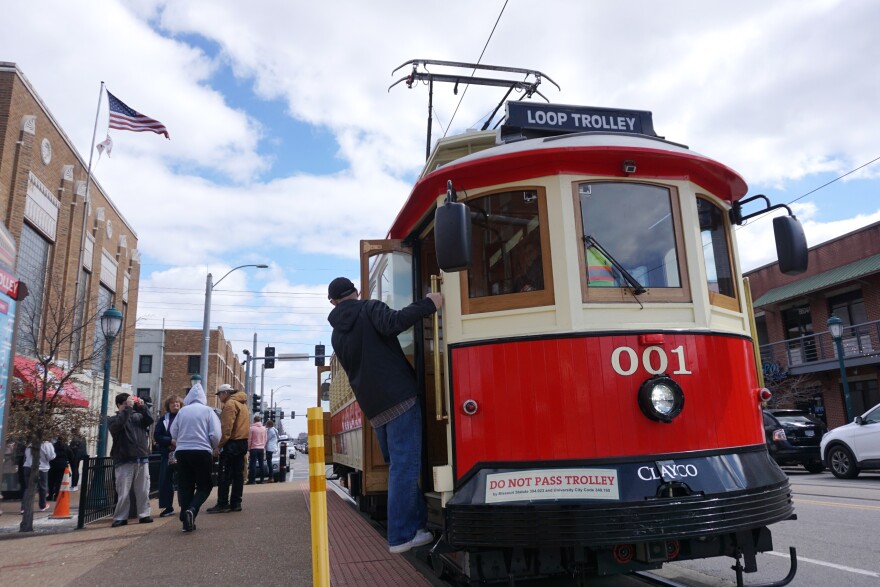
The Loop Trolley in the Delmar Loop has had a tumultuous history regarding its funding after it fell short of offering consistent services, and it often triggers strong feelings from residents and lawmakers alike. It’s been called an “abysmal failure,” a “troubled problem” and a nuisance for car riders. But it’s here to stay — at least through June 30, 2025.
It currently operates Thursdays through Sundays via a 2.2-mile route on Delmar Boulevard and DeBaliviere Avenue, between the University City Library and the Missouri History Museum in Forest Park.
There is no charge to ride the trolley, and no tickets or reservations are needed — just hop on!

Biking
The region offers various opportunities for cycling, whether it’s to get some exercise and enjoy the scenery or to commute around town.
Cyclists often pair their commute with public transportation since Metro buses and trains allow riders to bring their bicycles on board. Designated bike lanes are marked on city streets, but sometimes cyclist and motorist lanes are combined, which means cyclists must follow the same rules as motorists. Remember to always wear protective headgear and brightly colored or reflective clothing for safety.
There are roughly 156 miles of bike lanes in the city of St. Louis. Here’s a breakdown:
- Shared lane markings: 99 miles
- Bike lanes: 30 miles
- Buffered bike lanes: 24 miles
- Bike boulevards: 2 miles
- Protected bike lanes: 1.25 miles
- Velodrome cycling track (One of only a couple of dozen in the U.S.): 0.2 miles
The city's online bicycle routes map highlights bike facilities, paved trails and protected bike lanes, as well as greenway and city-funded projects in the works.
According to Great Rivers Greenway, there are about 128 greenways across the St. Louis region in Missouri and Illinois. (What's a greenway?)
Madison County, in the Metro East, has one of the most extensive trail systems in the St. Louis region. The MCT Trails system has 138 miles of paved bikeways that connect to trails in neighboring Jersey County, St. Clair County and across the Mississippi River to St. Louis.
Taxis and ride-share companies
Other means of getting around town besides biking and public transportation include taxis and carpooling. Companies that operate in St. Louis include:
If you have any questions, comments or ideas to add to this transportation guide, email welcome@stlpr.org.


